Sunday 6 May 2012

Challenge 4: Hillend: Length 2k, Difficulty 10/10

This run/hill climb is the first I have ever done that gets a 1 rating (the highest) on the Map My run Hill climb difficulty grading!  This is hardcore!!!

Challenge 4:
Length, Long: 2k
Difficulty: 10/10
Time approx:30min
Incine: 273m
Max Height: 441m
Start position: Bottom Carpark at Hillend (midlothian snowpsports)
End Position: Top of Cearkitten
Terrain: soft grass path (dangerous when wet)
Items needed: Shoes


Sunday 29 April 2012

Challenge 3: Murrayfield Loop: Length, 10k. Difficulty, 1/10

Challenge 3:
Length, Long: 10k
Difficulty: 1/10
Time approx:1hour
Incine: 135feet
Max Height: 292m
Start position: Roseburn Park (Murrayfield)
End Position: Back to the Park
Terrain: Mixed, road, canal path, wooded track.
Items needed: Shoes


This run is pretty darn easy and is a lovely one to do on a nice sunny day.  It starts and ends at Murrayfield, the international rugby stadium, Well the park just at the front of it, which is called Roseburn park.


You can park your car right beside the park for free, any day of the week but there are not many spaces so you may be hunting for a while. 

The first section of the run is towards the city centre, you run past Donaldson's School for the deaf, and past Haymarket train station. You then do a short hill up Morrison street and then take a right and head to Edinburgh Quay where the bar/club Cargo is. This is the start of the Union Canal which goes from Edinburgh to Glasgow (via the Falkirk wheel)  

That is pretty much all the uphill that you are going to encounter on this run. For the next 3.5k you are running along the canal which is as flat as a…. canal.


You run out to the viaduct where the canal crosses over the Lanark Road and then next viaduct just before you start to go over it you take the steps off to the right which takes you down to the Slateford/water of Leith visitor centre and you then start to make your way back to Murrayfield via the path that follows the Water of Leith.  
This path has a lot more twists and turns, you are more in the trees and the ground is more gravel and earth rather than road and path.


Once you get to the Stenhouse road, you cross over and keep following the water, this then takes you to the Saughton park where there is a skatepark and then you are on the last 2k home.

At the moment the path is blocked due to some rail works just at the railway pass before Murrayfield so I had to do a little diversion via Sainsbury's and around the front of Murrayfield to get back to the park.
But otherwise it is just a case of follow the water and you get back to the park.


Challenge:
+1 point for ever minute faster than an hour 
-1 point for ever minute slower than an hour


Sunday 15 April 2012

Edinburgh Fitness Challenge 2: Harlaw Loop Long. Length, Long, Difficulty 3

Challenge 2:
Length, Long: 14k
Difficulty: 3/10
Time approx:1:40h-2:20h
Incine: 175m
Max Height: 371m
Start position: Fence at carpark for Harlaw
End Position: Back to the Fence
Terrain: Mixed, walking stone path, grassy rutted path, and road.
Items needed: Shoes


This is a long challenge, over 14k and has 2 inclines with more than a 3% gradient.  Google maps struggles to give a satellite image of the location as it is slightly covered in cloud and low resolution as there is no urban area.


You start point is at Harlaw carpark, this usually gets pretty busy with visitors and walkers so either get there early or share a car if you are doing this with a group.
The challenge is a loop and the end point is the same as the start point.


from the carpark you head directly for the hills. Following the path, you will be in good company with lots of other walkers and mountain bikers.
The first 2k are a gentle uphill through some fields.  This is a good one for getting the heart going fast so you may want to do a couple of intervals here of walking and jogging.
Once you reach the peak you climb over a wall and then can see over to Flotterstone, and the Glencorse reservoir, this is the fun downhill part. the ground is part grass, part mud part stony and all very rutted up so most of the time you will have your eyes down on the ground watching your step so as not to twist an ankle and to jump any muddy bits.


Once you reach the bottom of the hill you have done about 3.8k, take a right and then you are on a nice bit of flat road for a little while. You  are jogging along the side of the Glencorse reservoir, very picturesque.
You may see some geese and a Herron if you a lucky.


Follow this road and try and get a pace going.  From 5k to 6.5k you have a little more of an uphill as this takes you up to the Loganlee Reservoir where there will be a lot of fishermen spending the day.  Once you hit that reservoir you get a nice flat stretch and there is even a loo if you are bursting.


As you get to the end of the reservoir, you go past a super scary house on your left with a scary swing in the garden.  do not do a night run here as there will be ghosts around.
From here you are back onto grass and dirt, no more road for a little while.
You weave your way through a valley and follow a trickle of a stream that leads up to a sweet waterfall.  This actually becomes a bit of an uphill but as the terrain is so flowing you dont actually notice much of an incline. SO much so that i was surprised to see that it is an other incline on the  gradient map above from 7-9k. I still dont believe it really.


This valley i suspect can get quite windy, which could either help or hinder depending on the direction.
Once you get out of the valley you come into open land and then to a fence where you cross over and then you start running on a road again and pass some fields with horses.
Say hello to the horses


Then you have a steep downhill, its short, about 500m and it is interesting to just go as fast as you can.  Doing so really really works out the lungs and the thighs.  after that you have flat road for a little then you can take a little short cut through a little wooded part to get you to join onto the walk that is along the side of the threipmuir and Harlaw reservoirs. This is where you have to dig deep and really focus on just doing it. IF you are fitter then try and get up  a faster pace here, if like me you are not so fit. just do your best to keep a constant jog on all the way to the end.


Challenge:
1 point awarded for ever 2 mins faster than 1h, 45m
1 point deducted for ever 2 mins slower than 1h,45m

Edinburgh Fitness Challenge 1: Arthur's Seat,(Direct route) Length, Short: Difficulty:9

Challenge 1:
Length, short: 1k
Difficulty: 9/10
Time approx:15mins
Incine 145m
Max Height: 225m
Start position: Monument at Holland house entrance to Holyrood Park
End Position: Top of Arthur's Seat
Terrain: Rocky path
Items needed: Shoes


This is a short run but is super intensive and almost just a constant uphill, with a very steep gradient of 14%.   It can be completed in under 15 minutes and you are rewarded with amazing views all over Edinburgh.
The start position is at the Monument at the Holland House / Pollock halls  entrance to Holyrood park. From there you aim directly to the top of Arthurs seat.  You quickly cross the Queens Park road and go off into the hill, The first point is the valley at the end of the Crags, here is where you can see north to the park and West where you have come from.  Here you then look at the mountain right in front of you and you aim for the zigzag rocky path that is the most direct route.

The path is made up of random rocks, which are uneven and irregular, be careful where you step, although generally they are all securely in place, it can be easy to twist an ankle if not paying attention. 
This will have your heart rate racing and even when you slow down to a walking pace your heart rate will still remain high.  If you are able do do it all in a jog pace, you are truly super human.

This route may get busy later on in the day and there may be children with adults clambering up so be careful not to bosh some child off the path and have them fall down the hill.  

The path then levels out for a moment as you run more around the top of the hill then you have a left turn and it is a slog back up hill again.  once you reach the top of that path you then come over the horizon and from there you are then able to see the final end spot. but you have to do a little down hill, try and run this, the ground is smooth and grassy (watch out if it is wet) and try and keep up your speed as you tackle the last incline which is almost just total rock and thus almost no official path has been eroded into it.  This is almost a scramble.  Get to the top and touch the Cairn.


And that is it.

But
The downhill is far trickier.  This is not part of the challenge as I would classify it as too dangerous to try and race it.  And it is also very possible to get lost as you will see in the video.


Challenge:
1 point awarded for ever 15 seconds faster than 14m:30s
1 point deducted for ever 15seconds slower.

1 point awarded for ever kg heavier than 90kg
1 point deducted for ever kg less than 90kg

Edinburgh Fitness Challenge Blog Introduction

This blog is for me to put up fitness challenges for doing some workouts in and around Edinburgh and possibly further afield.

If you want to take part please post your own times and if you have the ability, record your run on Mapmyrun app on your phone and post your results to the facebook page.

If you want to take part in a points based challenge,
The calculations are this.

My results are based on me being 90kg in weight.
for every 15seconds you are faster, award yourself 1point
for every 15 seconds you are slower, deduct 1 point

For every kilo heavier than me you are, award yourself one point
for ever kilo lighter than me, deduct one point.

Example, Lighter:
I run a 15minute challenge
you weigh 85kg and it takes you exactly 15mintues as well , Your score = -5
you weigh 85kg and it takes you 13m45s your score = 0
you weigh 85kg and you do it in 13m, your score = +3

Example; Heavier:
you weigh 100kg and it takes you 15minutes, your score is= +10
you weigh 100kg and it takes you 17m,30s, your score = 0
you weigh 100kg and it takes you 20m, your score = -10


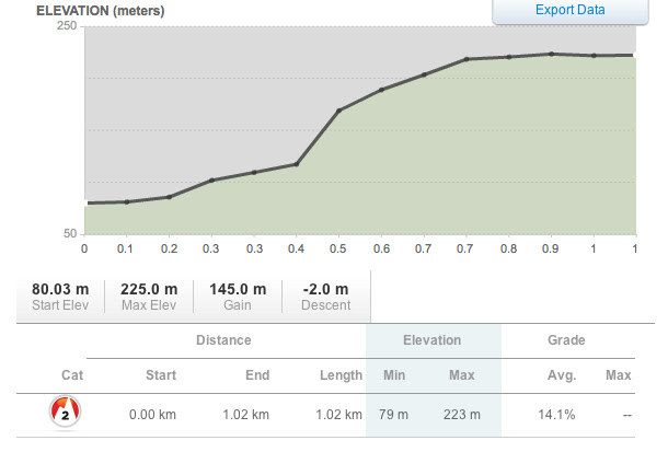
For each challenge there will be basic information regarding the challenge, consisting of
Distance
Rough length of time to complete
Subjective difficulty rating
Incline
Max altitude
and Items needed:
Items need can be: warm clothes; water bottle; map; food; etc